Ready to explore Iceland?
In this guide, we’ll take you through the best spots around the south of Iceland. Whether you’re chasing waterfalls, stunning landscapes or hidden hot springs, this is your ultimate resource to plan the perfect route.
⚠️ Important Note Before You Plan Your Route…. (Click Here)
We recommend reading our general travel guidelines before organizing your itinerary around Iceland. The weather here is unpredictable and can change rapidly, especially in winter. Some roads — even those that seem accessible on the map — may become difficult or even impassable depending on the season and conditions.
It’s also impossible to see everything in one trip, so we suggest selecting your top priorities based on the time you have available, your fitness level, and road safety updates.
Don’t underestimate driving distances either — even short routes can take longer due to road conditions, photo stops, and the sheer beauty that will tempt you to stop often!
Important to check weather and road conditions at Vedur.is, Road.is or SafeTravel.is
Check our Travel Guide to Iceland – Essential Tips for a Perfect Trip
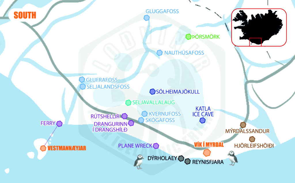
THE SOUTH OF ICELAND
What to do in the South of Iceland? (Part 1/2)
From Selfoss to Vík í Mýrdal
South Iceland is a region packed with some of the country’s most iconic landscapes: towering waterfalls, massive glaciers, black sand beaches, and remote islands. It’s the perfect road trip route, stretching from the famous Seljalandsfoss waterfall to the charming village of Vík and beyond.
You’ll pass through a land of contrasts — where volcanoes meet the sea, and folklore lives among cliffs and caves. Whether you have just a day or a full week, this guide helps you plan the best stops in the south.
📍SELFOSS 🏘️
Selfoss is the largest town in South Iceland, with a population of around 9,000 people. While it may not be a tourist hotspot itself, it’s a practical stop for fuel, groceries, and restaurants when exploring the Golden Circle or heading east along the south coast.
📍GLUGGAFOSS WATERFALL (MERKJÁRFOSS) 🌊
Gluggafoss, also known as Merkjárfoss, is a beautiful, lesser-known waterfall where the river Merkjá drops through cliffs riddled with natural rock windows or “gluggar” — giving the falls their name.
- Minim Visit Duration: 30 min
- Difficulty level: Very easy. Short walk from the parking area.
- Free. Not touristic place.
📍 NAUTHÚSAFOSS WATERFALL 🌊
Nauthúsafoss is a lesser-known waterfall close to Seljalandsfoss. It features a two-tiered drop framed by rugged cliffs, and while small compared to its neighbors, it offers a quiet, scenic stop away from crowds.
- Not essential if you’re short on time.
- Minim Visit Duration: 10 – 15 min
- Difficulty level: Easy – visible from car.
- Free, but private land (NO trespassing, do not get that closer).
- Curiosities:
- The name means “Cowhouse Falls”.
📍SELJALANDSFOSS & GLÚFRÁRFOSS (GLJÚFRABUI) – WATERFALLS 🌊
Seljalandsfoss is one of Iceland’s most iconic waterfalls, famous because you can walk behind the waterfall curtain.
Just behind Seljalandsfoss, a 40 m waterfall hidden inside a narrow gorge, Gljúfrabui, partially obscured by a cliff—known as “dweller of the gorge.”


- Minim Visit Duration: 30 – 40 min (both waterfalls)
- Difficulty level: Easy, moderate.
- The path behind Seljalandsfoss can be slippery. High probability to get wet.
- Same inside Gljúfrabui.
- Small parking fee.
- Curiosities:
- Seljalandsfoss is fed by the glacial river Seljalandsá, originating from Eyjafjallajökull glacier.
- The falls drop about 60 meters (197 feet).
📍FERRY TO VESTMANNÆYJAR (WESTMAN ISLANDS) ⛴️
The Vestmannaeyjar Ferry takes you to the Westman Islands, specifically Heimaey, the only inhabited island. The ferry ride crosses the rough Atlantic but only takes about 35-40 minutes.
The Vestmannaeyjar (Westman Islands) are an archipelago of 15 volcanic islands, but Heimaey is the only inhabited one. It’s a unique destination with volcanoes, puffins, lava fields, and dramatic cliffs — a world of its own just off the south coast.
- Difficulty level: Easy with some optional moderate hikes.
- Minim Visit Duration: One day.
- Home to the world’s largest puffin colony. Visit between May and August for puffin season.
- Curiosities:
- In the Puffling Patrol tradition, local kids rescue stray baby puffins each summer.
- The 1973 eruption nearly closed the harbor, but locals pumped seawater to divert the lava flow — saving the town.
SOON WE WILL CREATE A POST SPECIALLY ABOUT THIS.
📍RÚTSHELLIR CAVE 🏘️
Rútshellir is a man-made cave, considered to be one of the largest artificial caves in Iceland, carved into volcanic rock. Historically, it served as a barn or shelter, but its origins are believed to be much older, possibly even from Viking times.
- Minim Visit Duration: 10 – 15 min
- Difficulty level: Easy.
- Free
- Curiosities:
- Local legend says the cave was home to a giant named Rútur, who was eventually killed by a local farmer.
- Rútshellir is mentioned in Njáls Saga, one of Iceland’s most famous sagas.
- The cave’s purpose remains partly a mystery — some suggest ritual use, others as shelter or storage.
📍DANGURINN Í DRANGSHLÍÐ – TRADITIONAL TURF HOUSES 🏘️
Drangurinn í Drangshlíð is a large standalone rock (drangur) with turf-covered farm buildings built right against it. This dramatic setting blends nature and architecture, embodying Icelandic rural history and folklore.

- The farmstead structures are a prime example of Iceland’s turf house tradition combined with natural rock formations.
- Minim Visit Duration: 5 – 10 min
- Difficulty level: Very easy.
- If it is close for entry – do not trespassing.
📍ÞÓRSMÖRK VALLEY (ONLY 4X4) 🗻
Þórsmörk is a lush, green valley between three glaciers: Eyjafjallajökull, Mýrdalsjökull, and Tindfjallajökull. It’s a popular hiking paradise, famous for dramatic mountain peaks, braided rivers, and forested areas — rare in Iceland.
- No direct access by regular car. Only 4×4.
Access to Þórsmörk itself is rugged due to river crossings. Only for experienced drivers with river crossing.
Important to check weather and road conditions at Road.is or SafeTravel.is
- Possibility to acces with a HIGHLAND BUS (10-15.000 isk one-way).
- HIKING TRAILS
- Fimmvörðuháls trail (from Skógafoss)
- Laugavegur trail (to Landmannalaugar)
- Shorter local hikes like Valahnúkur for panoramic views like glaciers, canyons…
- Minim Visit Duration: One full day.
- Difficulty level: Moderate to challenging, depending on the specific hike.
📍SKÓGAFOSS WATERFALL 🌊
Skógafoss is one of Iceland’s most famous and powerful waterfalls, with a 60-meter (197 ft) drop and a 25-meter (82 ft) wide curtain of water. On sunny days, the mist often creates double rainbows, making it a magical sight.

- Minim Visit Duration: 30 – 60 min. Longer if hiking.
- Difficulty level: Easy, visible from parking. Stairs up to the base of the waterfall may be tricky, specially attention if strong wind.
- Curiosities:
- Skógafoss has been featured in movies and TV shows like Vikings and Thor: The Dark World.
- The river Skógá that feeds the falls is glacial, originating from Eyjafjallajökull and Mýrdalsjökull glaciers.
📍KVERNUFOSS WATERFALL 🌊
📍Kvernufoss is a hidden waterfall tucked inside a gorge, often overlooked by tourists. It drops 30 meters in a narrow canyon, and like Seljalandsfoss, you can walk behind the waterfall.
- Minim Visit Duration: 45 min.
- Access the trail from behind Skógar Museum.
- Difficulty level: Easy to moderate.
- Curiosities:
- Despite being so close to Skógafoss, it remains relatively unknown to mass tourism.
- Locals sometimes call it the “secret sibling of Skógafoss”.
📍SELVALLALAUG (HIDDEN POOL) 🛁
Seljavallalaug is one of the oldest swimming pools in Iceland, built in 1923, nestled in a narrow valley surrounded by steep green mountains. The pool is partially filled with geothermal water, making it warm but not hot.
- Minim Visit Duration: 1 – 2 hours if bathing.
- Difficulty level: Easy, 15 – 20 min from parking lot.
- Free. No changing rooms or facilities. It has minimal maintenance, probably not the cleanest pool.
- The water is lukewarm, not hot — better on sunny days.
- Curiosities:
- Originally built to teach Icelanders how to swim. The pool has become a semi-abandoned yet beloved secret spot for visitors.
- After the 2010 Eyjafjallajökull eruption, the pool was filled with ash but was cleaned by volunteers.
- Despite its popularity, it remains a raw and rustic experience compared to modern hot springs.
📍 DC-3 PLANE WRECK – SÓLHEIMASANDUR ✈️
The DC-3 Plane Wreck is the abandoned remains of a US Navy aircraft that crash-landed in 1973 on the black sand beach of Sólheimasandur. All crew survived, but the wreck was left behind and has since become an iconic, post-apocalyptic landmark.
- Difficulty level: Moderate. 7 km round-trip flat hike across exposed, windy terrain. No shade or facilities on the trail.
- There is the option to take a shuttle bus from the parking.
- Minim Visit Duration: About 2-3 hours (round-trip walk + visit).
- If bad weather or windy, can be more.
- Small parking fee. Shuttle Service has extra cost.
- Curiosities:
- The wreck is a Douglas C-117D, a military version of the DC-3.
- The crash was due to severe icing and fuel exhaustion (or a gauge failure, sources vary).
- Featured in several pop culture pieces, including Justin Bieber’s music video (“I’ll Show You”), and some films.
📍DYRHÓLAEY CLIFFS 🖤
Dyrhólaey is a dramatic promontory with towering cliffs, offering spectacular views of the black sand beaches of Reynisfjara, the Dyrhólaey Arch, and endless ocean panoramas. It’s also a prime location to see puffins during summer.
- Spot puffin nesting (May to August).
- Difficulty level: Easy
- Minim Visit Duration: 30 – 60 min (longer if bird watching).
- Small parking fee. Shuttle Service has extra cost.
- Curiosities:
- The name means “Door Hill Island”, referring to the large arch-shaped rock that boats can pass under when the sea is calm.
- Dyrhólaey is the southernmost point of mainland Iceland.
- The lighthouse dates back to 1927.
📍REYNISFJARA BLACK SAND BEACH + HÁLSANEFSHELLIR CAVE 🖤
Reynisfjara is Iceland’s most famous black sand beach, renowned for its towering basalt columns (Hálsanefshellir cave), the Reynisdrangar sea stacks, and powerful waves of the Atlantic. It’s visually stunning but also one of Iceland’s most dangerous beaches due to sneaker waves.


- EXTREME CAUTION WITH SNEAKER WAVES. RESPECT THE SAFETY INDICATIONS ON PLACE.
NO SWIMMING. DON’T GET CLOSE TO THE SHORELINE. SNEAKER WAVES ARE UNPREDICTABLE. - You may spot puffins on the cliffs (May to August).
- Difficulty level: Easy
- Minim Visit Duration: 30 – 45 min
- Small parking fee.
- Curiosities:
- Named one of the world’s most beautiful non-tropical beaches by National Geographic.
- The basalt columns are similar to those at Giant’s Causeway in Northern Ireland.
📍VÍK Í MÝRDAL VILLAGE 🏘️
Vík í Mýrdal, commonly just Vík, is a small coastal village nestled beneath steep cliffs, famous for its proximity to Reynisfjara, Reynisdrangar sea stacks, and its picturesque red-roofed church overlooking the town. It’s also the last major service stop before heading further east
- Good place to refuel, restock groceries, or stay overnight.
- We recommend a quick stop, at least, in SKOOL BEANS CAFE
📍HJÖRLEIFSHÖIÐI CAVE (YODA CAVE) 🖤
Yoda Cave is a large sea cave at the base of Hjörleifshöfði Mountain, famous for its entrance shaped like the face of Yoda from Star Wars. Although it has no connection to the movies, it’s become an iconic and quirky photo stop on the South Coast.
- The cave formed from ancient sea erosion when this area was submerged under water. The resemblance to Yoda’s face is purely coincidental but fun!
- Difficulty level: Very easy
- Minim Visit Duration: 10 – 15 min
- Curiosities:
- The mountain was once an island, surrounded by sea before glacial floods filled the area with sand.
📍KATLA ICE CAVE (Only Guided Tours) ❄️
The Katla Ice Cave is a natural ice cave formed in the Kötlujökull glacial tongue, a part of Mýrdalsjökull glacier. It’s famous for its layers of blue ice and black volcanic ash, creating dramatic, otherworldly patterns. It’s one of the few ice caves in Iceland that can be visited year-round.
- Difficulty level: Easy to moderate — short walks on ice with provided gear.
- No prior glacier experience needed.
- Minim Visit Duration: 3 – 4 h
- Aprox. Price: 20-25.000 isk
- Booking in advance is recommended, especially in summer.
- Curiosities:
- The cave is formed and reshaped by meltwater and volcanic heat, so it can change appearance each year.
- The Katla volcano beneath the glacier is one of the most monitored in Iceland due to its eruption potential. Katla is said to erupt roughly every century — the last major one was in 1918.
📍MÝRDALSSANDUR BLACK DESERT 🖤
Mýrdalssandur is an immense black sand desert, formed by centuries of glacial floods (jökulhlaup) caused by eruptions of Katla volcano beneath Mýrdalsjökull glacier. This vast, barren plain is both eerie and breathtaking — a true Icelandic wilderness. You drive through on Route 1.
- Mýrdalssandur is not a formal stop, it’s a landscape you drive through on Route 1.
- DO NOT DIVE OFF-ROAD.
Where to Take a Bath in the South of Iceland?
SOON WE WILL POST A MAP WITH ALL THE PLACES WHERE YOU CAN RELAX AND ENJOY IN THE WATER IN ICELAND.
But meanwhile, here you have a list with some suggestions on the area:
- SELFOSS SWIMMING POOL (SELFOSS)
- SELVALLALAUG (NEAR SKÓGAFOSS)
- SWIMMING POOL (VÍK Í MÝRDAL) 💵
Discover More About Iceland
Travel Guide to Iceland – Essential Tips for a Perfect Trip

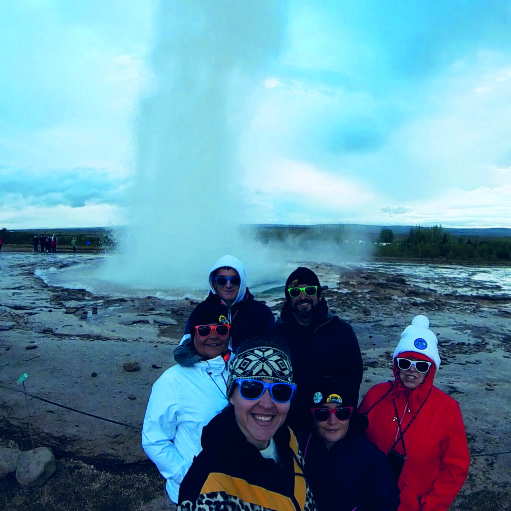
Discover Iceland with your LOÐVINIR Friends!
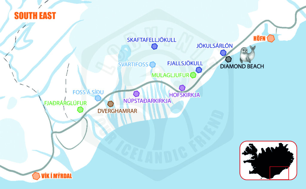
ICELAND GUIDE: SOUTH EAST (FROM VÍK TO HÖFN)
ICELAND GUIDE: SOUTH (FROM SELFOSS TO VÍK)
Handmade. Natural materials. Hypoallergenic.
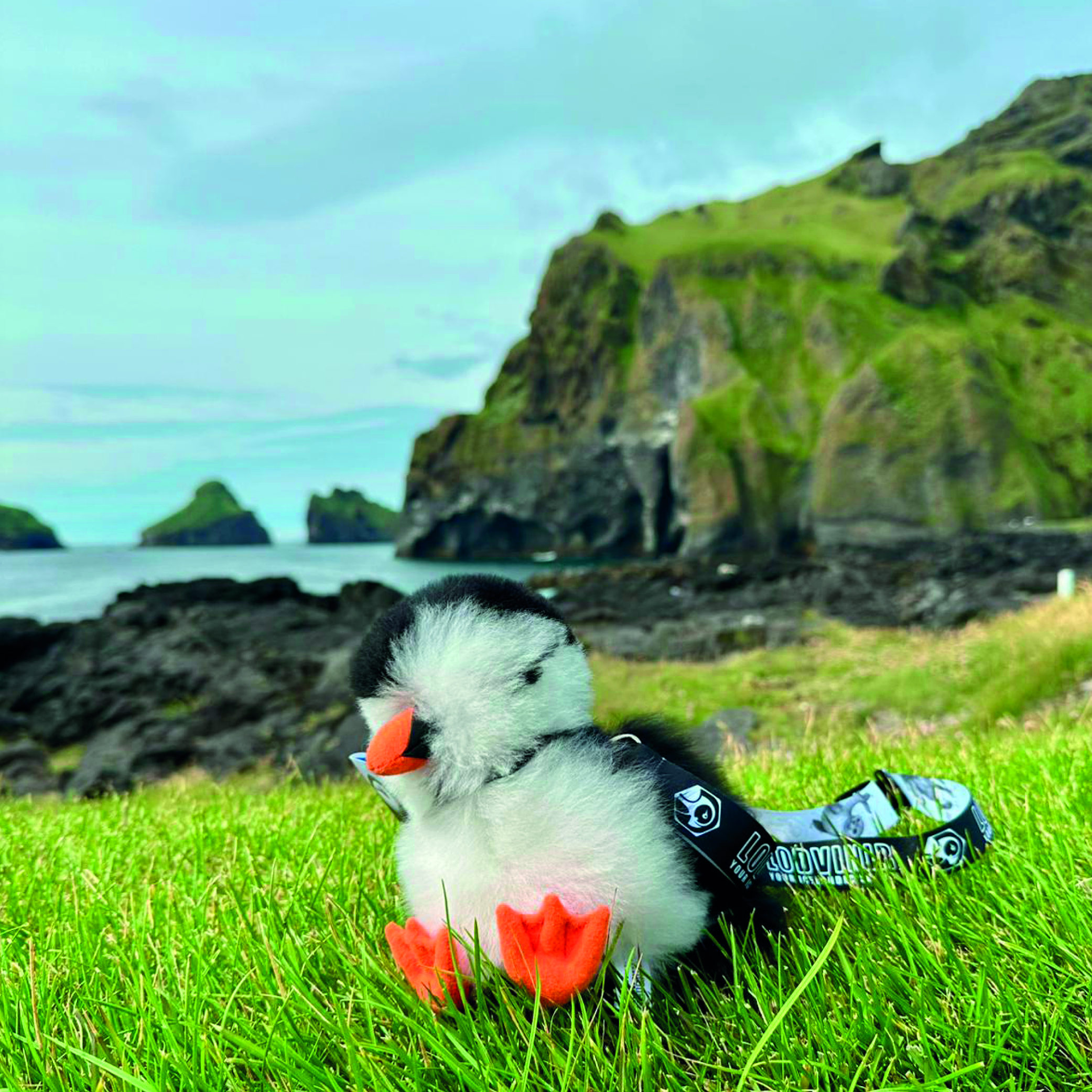
Adopt an Icelandic Puffin Plush – The Perfect Souvenir
Soft. Eco-friendly. Designed in Iceland.
Helps support Icelandic wildlife conservation.